Nepal Hiking Trek Airport Personnel will receive you upon your arrival in Kathmandu Airport and transfer you to the hotel in Kathmandu. The overnight dinner will be hosted by Nepal Hiking Trek to mark your arrival in Nepal Overnight in Kathmandu.
Day 01 Arrival in Kathmandu (1300m/4264ft).
Day 02 Kathmandu: Sightseeing and Trek Preparation.
After breakfast, this is the day for the sightseeing of the UNESCO WORLD HERITAGE SITES and also for the briefing of the trekking. Places like Durbar Squares of Kathmandu & Patan, Swyambhunath, Bouddhanath, and Pashupatinath will be visited during sightseeing. Overnight in Kathmandu.
Day 03 Fly from Kathmandu to Nepalgunj
The flight will take you to the flatland terai region of Nepal often considered as the hottest place i.e. Nepalgunj. During day time visit of the mini zoo or local market is taken place. Overnight in Nepalgunj.
Day 04 Fly from Nepalgunj to Jhupal (Dolpo) (2,320m/7,610ft).
Trek toDunai (2,850m/9,348ft): 45 mins flight, 2-3 hours trek, The flight from Nepalgunj to Juphal is splendid as the trekkers will get glimpses of the Annapurna series and Dhaulagiri. The scenery of the hilly landscape and villages on the trail towards Dunai is stupendous.
Day 05 Dunai to Ankhe (2,896m/9,499ft): 5-6 hours.
We leave Dunai and cross a suspension scaffold and swing toward the west taking after a trail past a doctor's facility. The trail climbs up the side of the treeless, Thulo Bheri valley before entering Phoksundo waterway valley. Amid the walk, we get to the perspective of Kagmara Peak up the valley. We pass through walnut forests, Dhera and Rahagaun towns, stroll down thick wildernesses lastly achieve Ankhe.Overnight in Ankhe.
Day 06 Ankhe to Sulighat: 5-6 hours.
Our trail rises and dives along a lush riverbank and ascensions on a soak trail. The high points and low points can be somewhat tedious; however, there are a few streams en route that offer an opportunity to chill. The trail, in the long run, leaves the woodlands and goes through a green slant high above the waterway. We trek downhill on a trail encompassed by lavish timberlands sometime recently achieving a precipice took after by a bewildering drop on an unstable stone staircase to the waterway bank. We keep trekking until we achieve Sulighat where we spend the night.
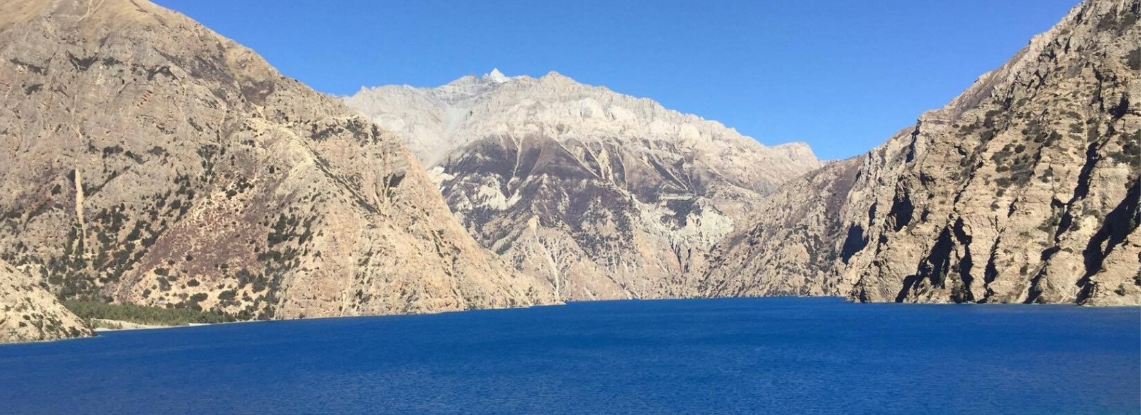
Day 07 Sulighat to Phoksundo Lake (3,611m/11,849 ft) 4-5 hours
We proceed with our adventure along the valley floor to the conversion of the Phoksundo and Pungmo waterways. Subsequent to the intersection a scaffold, we stroll on the western bank of the Pungmo Khola. The trail goes through cedar woodland before achieving Palam town. From here we trek up to an edge and appreciate removed perspectives of Phoksundo Lake and an astounding waterfall, one of the most noteworthy in Nepal. Next, our trail slides through birch timberlands to the upper compasses of the Phoksundo Khola, and afterward to the pleasant Ringmo town with its mud-put chortens and mani dividers. From here it is a short stroll to the shores of the Phoksundo Lake. Overnight at Phoksundo Lake.
Day 08 Today will be a merited rest day for acclimatization at Phoksundo Lake.
Amid the day we can leave on a short climb to the town of Ringmo and it's Tibetan Buddhist Monastery. Amid our short strolls, we likewise get an opportunity to get to know the neighborhood culture. The Dolpo individuals wear a homemade dress that is some of the time colored maroon shading and they support Tibetan-style somba or dacha (boots with upturned toes) for footwear. Both men and ladies regularly wear religious talismans and strings of coral, golden and turquoise. Overnight at Phoksundo Lake.
Day 09 Trek to Phoksundo Khola: 4-5 hours.
Our trail moves around the top western end of the Phoksundo Lake as it forms on a rough edge along the lake's western bank. This insecure trail suspended on a passage of wood bolstered on pegs crashed into a chasm in the stones, flags the remoteness of the territory we are going to enter. At the westernmost edge of the lake, the way leads through a lavish knoll that opens up into the surge plain of the Phoksundo Khola. At that point we stroll through the valley, crossing the waterway and keeping away from the infrequent boggy swamp underneath and afterward going ahead of the bank of the stream to the overnight camp.
Day 10 Phoksunds Khola to Phoksundo Bhanjyang: 6-7 hours
For 60 minutes or so we stroll on a trail that leads us along the level way through a chilly valley which heads due north. At the intersection of the Phoksundo Khola and another mountain stream, there is an old wooden connect. From here, we walk towards the north-east. A long climb brings us to a sheep knoll where our trail veers up a lofty gorge. A hard move to the top brings us to yet another valley where we can see the Kang-La pass. We set up our camp close to the go in a place that Peter Matthiessen initiated 'Snowfields Camp'. Amid our trek today we likewise get the opportunity to appreciate the perspectives of Chhamlang 6 (6739m) and mountain 7 (6105m).
Day 11 Phoksundo Bhanjyang to Shey Gompa (4,500m/14,760ft) via Kang-La pass (5,360m/17,581ft): 5-6 hours.
In the morning, we climb on a lofty trail covered with slate towards the pass. The move to the highest point of the pass is very strenuous. From the highest point of Kang-la pass, we get phenomenal perspectives of the vast valley analyzed by a spouting waterway. We dive to the valley floor on a lofty trail. Next, we stroll on a wandering trail along the banks of a waterway, crossing and re-crossing it a few circumstances. There are mud caverns coating the slopes disregarding the stream. We likewise go through glades where we see brushing yaks, several sheep and local mountain goat (Chyangra). After crossing an interesting log connect we come to the Shey Gompa compound where we will spend the night. Included meals:
Day 12 Acclimatization and rest at Shey Gompa.
Shey Gompa was implicit 1655 and the cloister is noted for its monster copper with the plated gold statue of a situated Shakyamuni Buddha. Toward the east of the gompa is Crystal Mountain which is one of the most unusual mountains, as its distorted bluffs are bound with quartz and installed with a rich assortment of marine fossils. Today is another all-around earned rest day for acclimatization. We spend the day climbing around Shey town which is well known for its old pre-Buddhist culture, the Bon Po. In Dolpo, the old Tibetan lifestyle consolidates animism with the instructing of Buddha. Overnight in Shey Gompa.
Day 13 Shey Gompa to Namduna Gaun (4,800m/15,744ft) via Saldang La (5,200m/17,056ft): 6-7 hours.
We start the day by taking after a charming trail in the midst of juniper trees which slides into a dark, stony gulch. At that point, the way starts to crisscross over exposed rocks and coarse dissolved soil until it, in the end, conveys us to the top of Saldang-la pass. The consequent drop towards the north is long and tiring however brushing yaks and sheep, and migrant tents produced using yak hair is an encouraging sight. In Namduna Gaun we visit Namgung religious community. The red stone monstery is worked against the scenery of a bluff on the north divider of a canyon. Overnight in Namida Gaun.
Day 14 Namduna Gaun to Saldang (3,620m/ 11,874ft): 4-5 hours.
We leave the town and ascend an incline and start a long stroll along dusty desolate mountains. Following 3-4 hours of a hard climb, we start to see Saldana Village beneath us on a level high over the Namga Khola stream. It has a beautiful appearance. Saldana is the biggest town of the inward Dolpo range. The town extends for about two kilometers on an open slant and comprises of five towns having around eighty well-manufactured houses with almost six hundred individuals. It is a prosperous town not just agronomically additionally for its vital area on an exchange course to Tibet.Overnight in Saldang.
Day 15 Saldang to Yangze Gompa (4,960m/16,267ft): 4-5 hours.
From Spalding, we walk advance north along the Nagon Khola (waterway) on a wild and infertile territory. We start our stroll on a genuinely continuous way with few good and bad times. In transit, we go through Marang and Ki towns. Next, we cross a tributary of Panzang River and walk towards the east and cross the stream again before achieving Yangze gompa which houses an old Bon-Po Monastery. Overnight in Yangtze Gompa.
Day 16 Yangze Gompa to Sibu (4,560m/14,957ft): 6-7 hours.
From Yangze, there are two trails that interface with Sibu. To spare time we will follow the way back towards Saldang town, which will be much simpler and shorter than the other course. From Spalding, we stroll along a stream and go through terraced fields, stupas, chortens, piles of mani stones and a Chaiba cloister, then go through the Namdo town, which is additionally prosperous, with around sixty houses having almost 400 tenants. It extends for more than 5 km on the high inclines to one side of Nam Khong Khola. The Namdo religious community is situated close to the stream bed. Our travel proceeds additionally down the waterway for an additional two hours to camp close to a little settlement of Sibu.
Day 17 Sibu to Jeng-la Phedi (4,900m/16,072ft): 5-6 hours.
Pass by the caravans moving to Tibetan border along the Nam Khong Khola. In the eastern part, we reach the junction of small streams next to the steep trail to ascend meadows just beneath Jeng La Pass. The camp will be in grazing spots or meadows. Overnight in Jeng la Phedi.
Day 18 Jeng-la Phedi to Tokyu Gaon (4209m/13809ft) via Jeng La pass (5,090m/16,695ft): 5-6 hours.
Early morning we head for our trekking to cross the Jeng La Pass. The view of Dhaulagiri Massif is outstanding from the top. Descend towards Tarap valley which is a very marvelous valley with plains up in the Himalayas. Camping is done near the Tokyu monastery.
Day 19 Tokyu to Dho Tarap(4,040m/13,251ft): 4-5 hours.
Descend further on a plain valley having the patches of green lush bushes on the banks of the river. This is absolutely different than inner Dolpo region. Overnight in Dho Tarap.
Day 20 Rest Day at Dho Tarap.
This is resting and general strolling day within the village of Dho Tarap. This actually helps in mingling with locals and finding their culture. Overnight in Dho Tarap.
Day 21 Dho Tarap to Tarap Khola (Kamakharka) (3,800m/12,464ft): 6-7 hours.
This day’s trekking descends towards the valley narrowing ultimately up to the canyon. The forest of juniper and rose bushes above the tree lines along with the herds of blue sheep are a usual sight for the day. Camping will be in Kamakura meadows.
Day 22 Tarap Khola to Khanigaon(3,150m/10,332ft): 4-5 hours
Continuous walking down the Tarap River canyon or alongside the river is a major feature of day’s trekking. The trace of the path might not be there on the trail which you have to heed the instructions of the trekking guide. The gorge walking could be adventurous and wilderness filled as well. The camping will be on the banks of Tarap Khola near Khanigaon.
Day 23 Khanigaon to Tarakot (2,537m/8,321ft): 4-5 hours.
Traverse along the village of Lalberi and pass through the dense forest to meet another canyon. Once you have reached Tarakot the visit of Sandul Gompa offers a majestic view of the surrounding landscape as well. The camping will be on the banks of the river near to police camp. Overnight in TarakotIncluded meals: Breakfast Lunch Dinner
Day 24 Tarakot to Dunai (2,140m/7,019ft): 5-6 hours
The trail follows Bheri River and reaches Byas Gadi for lunch. The easy trail follows from this place onwards until we reach Dunai.Overnight in Dunai.
Day 25 Dunai to Jhuphal: 2-3 hours.
Again from Dunai the trekking continues along the Bheri River relishing the beautiful terrain. Villages like Dhupichaur and Rupgad are crossed before reaching the small airport or airfield of Jhupal. Overnight in Jhuphal.
Day 26 Fly from Jhuphal to Nepalgunj and then to Kathmandu
We take the soonest flight from Jhupal to Nepalgunj. After coming to Nepalgunj, we profit to Kathmandu for the following accessible flight. Upon our landing in Kathmandu, we will be exchanged to our inn. There is nothing to do except for exchange messages with travel associates and arrange the photographs. To commend the fruitful culmination of our trip, we will have a goodbye supper at night.
Day 27 Rest day in Kathmandu.
You can spend this day shopping around Thamel or collecting back the memories of the trekking. This day is designed in case of contingency plans for the trip as well. Overnight in Kathmandu.
Day 28 Departure kathmandu.
Nepal Hiking Trek airport representatives will bid farewell you at Tribhuwan International Airport. Our glorious trekking ends here with promises to trek again in this beautiful Himalayan nation with us.


